GeoData Manager 4.10.8.16 Released
What’s new in Geodata Manager
This is a patch to correct a error caused by TeeChart 2015, which caused graph axis unit changing (using right-click) to stop working. This version of GeoData Manager has reverted to TeeChart 2014 to fix this problem.
GeoData Manager Version 4.10.7.31 Released
What’s new in Geodata Manager
This is an overview of new features in this version of GeoData Manager. For a fuller list of changes in recent versions of GeoData Manager see here.
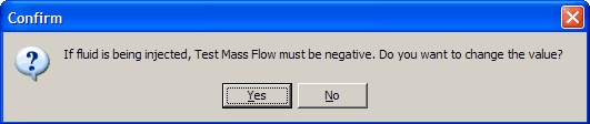
Add Many: A new command to import many data sets at one time, called Add Many. This is available for importing vertical wells, chemistry sample sites, geology rock sample sites and geophysics MT soundings: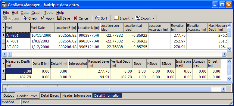
- A BROACH option has been added to Godevil data sets (clear well depth determination):
- For SHUT-IN downhole PT profiles, GeoData Manager enters zero mass flow data.
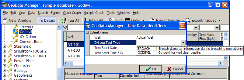
- If you enter a positive spinner mass flow, GeoData Manager asks if you want to change the sign to negative in case it is injection:
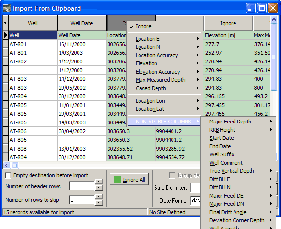
- NON-VISIBLE COLUMNS During Import, when you are assigning field names to the columns, you must click NON-VISIBLE COLUMNS to choose fields that are not currently visible in the header window. If you select one of these fields, GeoData Manager reminds you that the field is not visible:
- When entering reservoir data, GeoData Manager can automatically fill in some fields in the detail table:
- Database version now 33.
List of all changes in this version.
- General Improvements
- Database Changes
- Error Corrections
KEYLOK Install for Windows 8
KEYLOK has released its Windows 8 Install Program, available here (2.3 MB), or from the GeoData Manager and WellSim download pages.
If you are upgrading to Windows 8, you will need to download and run this Install Program to activate the KEYLOK dongles.
Installation Trouble-shooting
From the KEYLOK website:
To resolve 95% of installation snafus, follow these steps using our new Install Utility (Version 2014.3.2):
- Verify that the USB dongle is not plugged in.
- Run Install /b (install USB), or select USB from the Install GUI.
- Insert dongle when prompted.
- {Pre-Vista systems) Let the ‘Add New Hardware Wizard’ run.
- If any problems occur, view the log file [kl2log.htm] for details. It’s located in the same directory as the install.exe.
It is no longer necessary to run an ‘uninstall’ before reinstalling if an end-user inserts the dongle before installing the KEYLOK driver.
GeoData Manager Version 4.10.2.19 released
What’s new in GeoData Manager 4.10.2.19
New features in this version of GeoData Manager
Customization of Required Fields shown when adding new data
How to customize required fields (only available to Admin or Power Users).
1. Start GeoData Manager
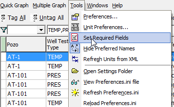
2. Select Tools | Set Required Fields from the main menu.
3. Double-click on fields in left pane to add them to the list of required fields.
4. Double-click on fields in left pane to remove them from the list of required fields.
5. Click on the Up and Down buttons to change the required field order.
6. Key fields (coloured blue) are always required.
7. You can change the order of the key fields by using the Up and Down buttons.
8. The required fields need to be specified for each node and each database.
Click on Tools | Set Required Fields
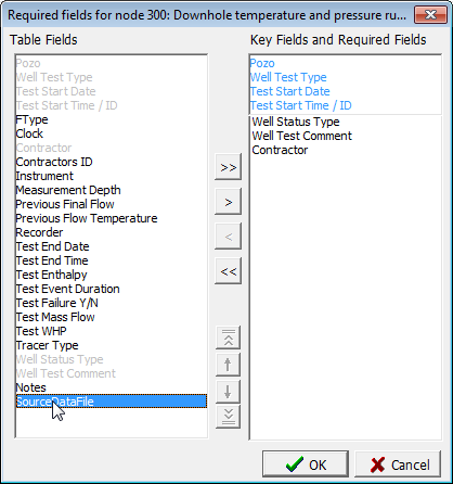
Double-click on field to add to Required Fields list
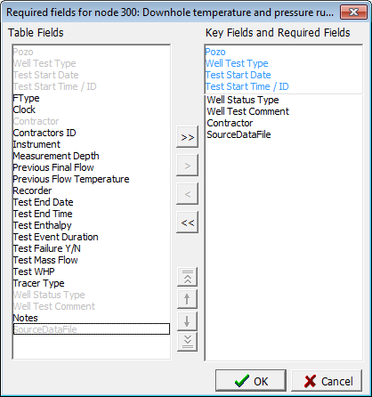
So simple to customize your required data fields
WellSim Version 4.10.1.17 has been released.
What’s new in WellSim 4.10.1.17
This is an overview of new features in this version of WellSim. For a fuller list of changes in recent versions of WellSim,refer to Recent Modifications.
New features in this version of WellSim
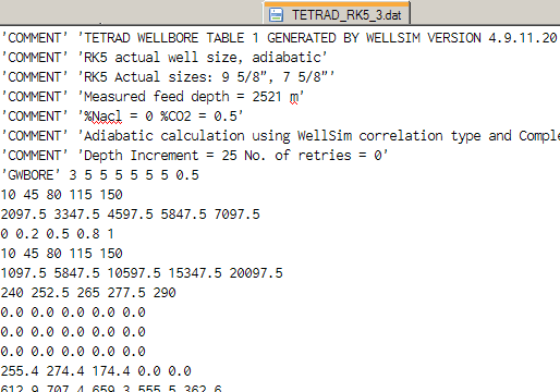
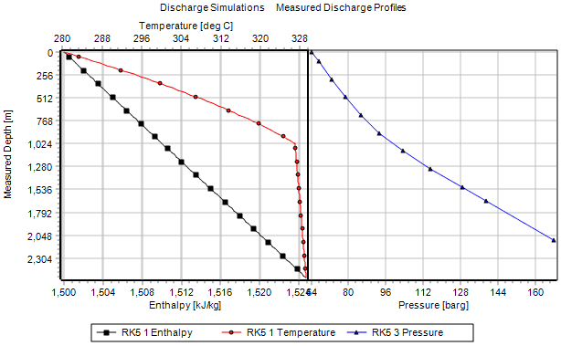
TETRAD Tables module
To calculate well data for TETRAD:
Side-by-side graphs
Multiple Graph can now display side-by-side graphs of data that share a common axis, usually depth:
The two side-by-side graphs revert to single graph if the dependent axes have same unit type.
Graphs
- Enhanced zoom: zoom all directions (all axes) or zoom independent axis only .
- Draggable axes in Quick Graph and Multiple Graph .
- Set axis increment to 0 to get good axis labels for normal graph and zoomed graph.
- Logarithmic axis labels improved; adjust axis labels by setting Increment.
And
In the Multiple Graph Group window, you can now select more than one field by Shift-clicking or Ctrl-clicking.
In the Column Ordering and Visibility window, you can now select more than one field by Shift-clicking or Ctrl-clicking. WellSim remembers the order that you Ctrl-click the fields and moves the fields in this order.
Database version changed from 8 to 9 for the new TETRAD module.
The Offical Launch Of The Software Website of GSDS Ltd
We are pleased to announce the official launch of our new website, gsds.co.nz that hosts download locations for all of the GSDS GeoData software programs, including GeoData Manager, WellSim, and Steamfield Manager. Here you will be able to find the most current versions of our software as well as previous versions, supporting software, online bug reporting, and media galleries. Be sure to visit our site frequently for important updates and news regarding GSDS GeoData software!
GeoData Manager is a comprehensive data management system that facilitates the storage, presentation and analysis of most data from a geothermal exploration and development program. WellSim is an integrated geothermal wellbore simulator and analysis package designed to allow ‘what-if’ scenarios. Steamfield Manager is specifically designed to handle both short-term and long-term data from an operating geothermal steamfield.